
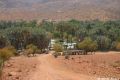


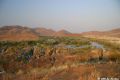
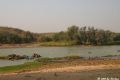
Today, we discovered paradise on earth! Last night we had a memorable stay in a Himba village about 30 km south of Okangwati. From there we cruised north along the reasonably well maintained gravel road towards the Angolan border. In years past, this road was only accessible by 4x4; now, even a two-wheel drive car can travel along this route. The arid landscape was a blend of yellows, browns and patches of incredibly intense terracotta, the same colour of the Himbas. We crested over a rise in the road and as if by magic, an amazing transformation took place in the landscape. The valley below was filled with lush green vegetation; between the abundance of palm trees one could see the Kunene River flowing.
welcome to Epupa Falls
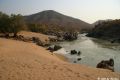
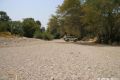
The waters of the Kunene flows quietly, leaving behind only a verdant corridor of life in an otherwise barren landscape. Palm trees, green grass and an abundance of life line the edges of the calm river; calm only until it splits into many rivers and creeks and then into dozens of waterfalls that cascade into the raging canyon below. A short distance past the canyon the water once again becomes calm and gracefully winds its way along the Angolan border. The rising mist from the canyon is pierced by the fiery rays of evening sunlight, casting a soft magical glow upon the majestic waterfalls.


abundance of bird wildlife


We spent two days at Epupa falls; resting, reading, swimming in the river, bird watching, hiking and last but not least, washing the dust out of the truck!
camping and playing at the Falls


Originally we had planned to explore the Kaokoveld and cross the challenging Van Zyl's pass. It is highly recommended that travel in this remote area only be undertaken with two or more vehicles in the group and this is why we initially embarked on our joint travels with Kate and Gareth. The route we chose was just under 800 km’s and would take us roughly seven days. This type of range would test the limits of our fuel supplies. Unfortunately, Kate and Gareth had to be in Lusaka at a specific time and still wanted to drive through Botswana. We all decided to push on together towards Ruacana and then down to Etosha. The road along the Kunene was slow going and 10 km's along the river, Kate and Gareth decided to turn back and travel on the less straining gravel roads to reach Etosha. It was a rather abrupt goodbye but inevitably our joint travels, which we really enjoyed, had to come to an end at some point. We made some loose plans to meet up in Etosha in a few days; plans that would never materialize as it took us another week to reach the National Park.
drive along the Kunene

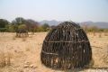
Himbas along the way


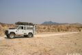

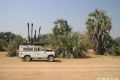
The first 100 km's along the Kunene River took us just over seven hours; very slow going. In a number of places we even had to engage low range. The drive was probably one of the most scenic since arriving in Africa. We spent a few nights camping at the Kunene River lodge and then headed back south with a stop in Opuwo and Kamanjab, before entering Etosha.
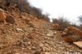
some rough 4x4 tracks


Having enjoyed the beauty of Epupa falls and the incredible biodiversity in the area, coupled with the knowledge of how important the river is to the Himba people, we are saddened by the prospect of a dam being built in this unique region. Please read on for some details about the proposed project.
The Kunene River is one of just five perennial rivers in arid Namibia, and is considered a precious resource by those who live near it. Namibia’s Kunene River valley is the ancestral home of approximately 12,000 Himba people, a semi–nomadic people who have lived there for more than 500 years, tending their flocks and making their sacred fires. The Himbas, who are one of Africa’s most successful remaining pastoralist peoples, have survived drought, war, genocide and other disasters, and now the most serious threat to their existence is the proposed Epupa dam. The reservoir would flood ancestral graveyards as well as critical dry–season grazing lands for which no suitable replacement land exists. In addition to flooding their remote oasis, the dam would bring roads, construction camps and development into their midst; introduce diseases common to the still waters of reservoirs, and potentially end the Himba way of life forever. Evicted from the area, they will also lose touch with their clans people across the river in Angola.
A report jointly authored by Earthlife-Namibia and a German environmental organization, Urgewald, states that "a resettlement for the Himbas would result not simply in a change of lifestyle but in their (Himbas) destruction". The project would also seriously affect downstream environments in the arid climate, and could harm the rich offshore fisheries. Hundreds of species rely on the river - the only year–round water source in the vicinity – and could be harmed by changes in its flow.
The Himba believe that building the dam would destroy their livelihoods and culture, and have strongly stated that they do not want the dam on their lands.
The government of Namibia has long intended to build a huge hydroelectric scheme on the Kunene. There are two possible locations. The first, the controversial Epupa site and the second at Baynes, 40 km downstream from Epupa. Unfortunately, the Baynes site has more or less been ruled out due to speculations of not being economically viable.
For the time being, the Epupa dam scheme is on hold, but time and again, large dams – even the most ill-conceived and destructive projects – have had a way of rising from the ashes.
There are alternatives to the dam scheme. Namibia is looking to develop its natural gas fields - construction on the Kudu project is expected to begin in 2006. Also, there is a strong potential for solar and wind power, but the Epupa project continues to be considered. With a looming energy shortage and a desire to be less dependent on South Africa (which currently supplies half the nation’s electricity), large dams such as Epupa, Popa Falls, and even faraway Grand Inga (on the Congo River) continue to be included in official energy planning documents.
Epupa dam is expected to produce 200 megawatts of power, although its output will likely be reduced in some years by drought – a serious problem for southern African dams. Climate change is likely to heighten the risks of hydroelectricity for the driest parts of Africa, a fact Namibia’s government recognizes (“The magnitude and reliability of power supply from [hydroelectric] projects will be impacted by climate change to a degree that is currently poorly quantified,” states a 2002 government report on climate change), yet it is still considering large dams.
The envisaged dam wall at Epupa would be 163 metres high, holding back 11,500 million cubic metres of water when the reservoir is full. A dam at the Epupa site would drown the Epupa Falls and cover an area of between 380 square kilometres when the reservoir is full and 161 square kilometre at a low water level. It would cause a loss of 380 square kilometres of grazing, displace some 1,000 people living in or using the dam area, and controversially inundate some 160 Himba graves and 95 cultural sites.
At Baynes, a reservoir of 2,600 million cubic metres of water would only cover 57 square kilometres of land when full. It would flood only 15 identified grave sites and affect less than 100 permanent users of the area.
Evaporation from an Epupa dam was calculated to be some 20 cubic metres of water per second, or 630 million cubic metres in a year - which would be eight times as much as at a Baynes site dam. Epupa Dam’s reservoir would evaporate twice as much water as the entire country uses each year – a major issue in a country that continually suffers from drought and water shortages!
A feasibility study on the Epupa scheme, funded by Norwegian and Swedish aid agencies, seemed to primarily make a case for the dam rather than thoroughly analyze its many drawbacks. Even before this flawed report was released, two senior Himba chiefs – Chief Paulus Tjavara, head of Himba traditional leaders in Okaoko, and headman Hikuminue Kapika – visited Europe to talk about the project and try to dissuade development banks and other investors from entering into the scheme. They also met with the director of the Norwegian agency writing the feasibility study, and asked them to stop funding the project "because you cannot imagine the serious consequences it will have. If you decide to fund the project, you will take part in destroying everything that belongs to the Himbas," Chief Kapika said.
The draft final report estimated the total price for the Epupa site project at US$539,4 million and the cost of the Baynes site project at US$551,2 million.
Acknowledged shortcomings in the draft final report - which had to be addressed before the completion of the final report - included the incomplete consideration of measures to lessen the impact on the Himba communities affected by the building of the scheme.
The final report on Namibia's lower Kunene hydro-power scheme states that the environmentally more damaging Epupa Falls dam site is the only economically viable option for the controversial project. Apparently the Baynes dam site 40 km downstream from the Epupa Falls is not economically viable because the operation of a hydro-electricity scheme there would be dependent on the regulation of the flow of the Kunene River by the war-damaged Gove Dam near Huambo in the Angolan highlands. Furthermore, it was stated that the Bayne site would be affected by drought more easily than a dam at the Epupa.